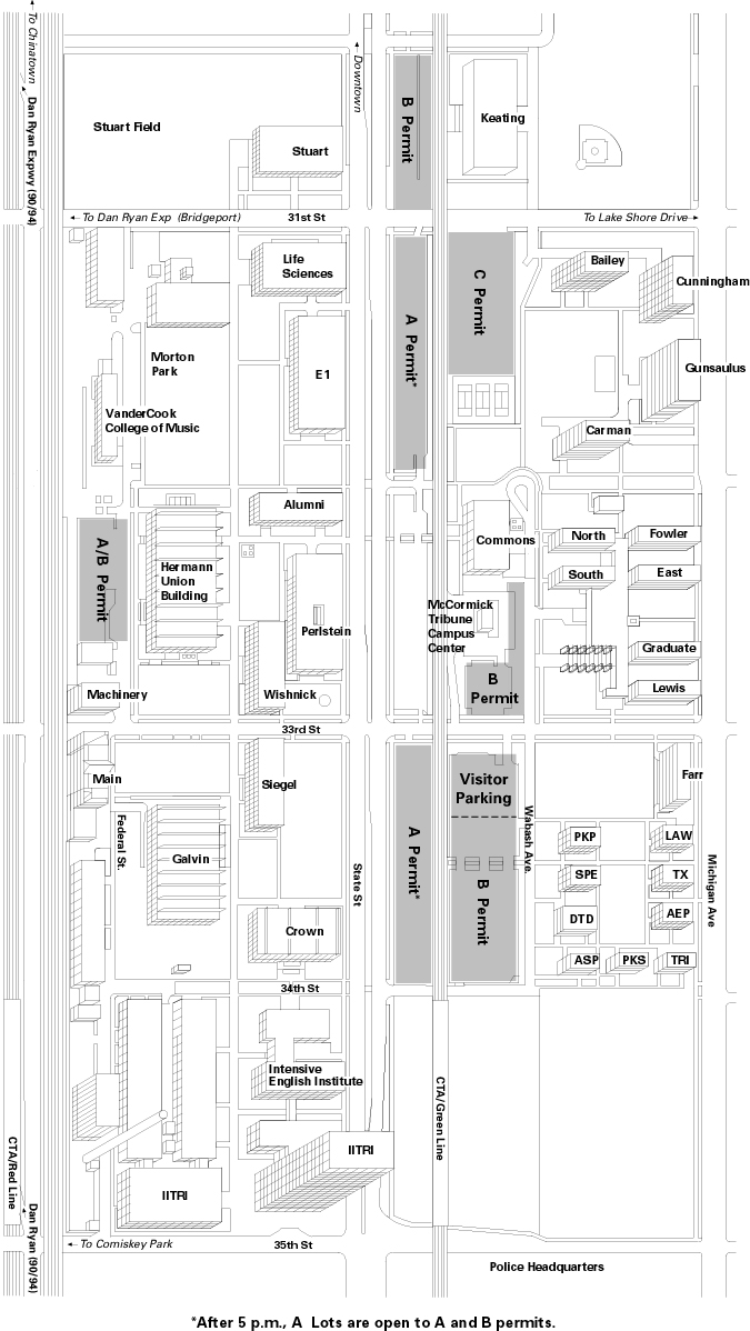
Physics is located in the Life Sciences building at the southwest corner of State and 31st streets. Building entrances are on the south side of the building near State Street, and on the west side of the building from the pedestrian walkway (formerly Dearborn Street). From anywhere on the campus, weather permitting, if you look for the tall downtown buildings, that's NORTH. On the map below, please note that at the present time 33rd Street is closed between the Dan Ryan Expressway and State Street.
From O'Hare and Midway Airports, you may reach IIT via public transportation, automobile, taxi cab, or limousine. Taxi cabs from O'Hare are metered and will cost $40-50 depending on traffic. Midway, also metered, will be $10-15 less. Limousines may be arranged for from call boxes located in the airport baggage claim areas, and will probably cost about the same as taxi cabs. Driving and public transportation are covered below.
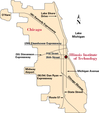
From O'Hare Airport (or the north and northwest suburbs), take the Kennedy Expressway, I-190 merging with I-90/94 (or the Edens Expressway, I-90/94) south and east toward and through the Loop (downtown) area to the Circle Interchange where the same roadway becomes the Dan Ryan Expressway.
From Midway Airport or the southwest suburbs, take the Stevenson Expressway, I-55, to the downtown area and exit south on the Dan Ryan Expressway (I-90/94) towards Indiana.
From the west suburbs, take the Eisenhower Expressway, I-290, to the Circle Interchange and exit South on the Dan Ryan Expressway, I-90/94, towards Indiana.
Exit the Dan Ryan at the 31st Street exit, proceed south along the frontage road (Wentworth Avenue) to 31st Street (the first traffic signal), take 31st two blocks east (left) to State Street, and then south (right) two blocks (1 traffic signal) on State Street to 33rd Street.
From the south suburbs, take the Dan Ryan Expressway, I-90/94, north to 35th Street. Exit at 35th Street, go 2 blocks east (right) to State Street, and then north (left) 2 blocks (1 traffic signal) to 33rd Street.
The visitor's parking lot is located on 33rd Street just beyond (east of) the elevated tracks.
IIT can also be reached by CTA rapid transit using the Green or Red lines, exiting at the 35th Street station of either line. The Green line station is on the IIT campus, whereas the Red line runs in the median strip of the Dan Ryan Expressway, one block west of IIT. At either station you should exit from the north end of the platform (at the rear of the train), which is 34th Steeet on the Green line, or 33rd Street on the Red line. IIT is an urban campus and caution should be exercised off the campus. If you should miss the 35th Street station, simply exit the train at the next station, stay on the platform, and take the next train in the opposite direction -- do NOT exit to the street.
To reach the Green line from O'Hare Airport, you take the Blue line train from the O'Hare CTA station on the lower level beyond the baggage claim area. Take the train to the Loop, transferring to the Green line at the Clark and Lake station. To get to the Green line, you go UP to the street level and continue UP onto the Elevated platform. Directions to the Green line are prominently posted at the station. You will want to take the train in the direction South toward 63rd Street. Transfers between rapid transit lines are free -- you do NOT need to buy a transfer, but you must exit the Clark/Lake station through the proper exit to get to the elevated without paying an extra fare. The one-way fare is $1.50, and you must buy a farecard from a vending machine at the airport station to enter the system. If you anticipate using the CTA during your stay in Chicago, you might consider one of the multi-day tourist passes, or purchasing a farecard with more than the basic fare. (A discount sets in at $10.) Information on fares as well as maps and schedules can be found here, as well as at the airport stations.
The CTA serves Midway Airport with the Orange line. You can transfer from the Orange line to the southbound Green line on the platform at Roosevelt Road. IIT (the 35th Street/Bronzeville station) will be the first stop after Roosevelt Road. Again, purchase a farecard for at least $1.50 at the airport before entering the system.
Should you decide for any reason to spend a few minutes downtown before coming to IIT, buy a farecard for at least $1.80. The extra 30 cents on the farecard will serve as a transfer valid for 2 hours from the last entry time on any CTA train or bus. From the Loop area you can then get to IIT via the southbound Green or Red train lines, or the southbound #29 State Street bus, which will stop at the corners of State and 31st, 32nd, and 33rd Streets. (There is no traffic signal (or street!) at 32nd Street, but there is a bus stop.)